Top of this page
Home
Model Output Archive
http://www.eol.ucar.edu/projects/ceop/dm/model/
http://ceop.wdc-climate.de
(Model Output Data Gateway)
Chair: Michael Lautenschlager (michael.lautenschlager@zmaw.de)
Ten operational Numerical Weather Prediction (NWP) and two data assimilation centers are currently contributing analysis/assimilation
and forecast model products from global and regional NWP suites, including both operational and reanalysis systems to this component of CEOP.
The contributing centers include:
- BoM: Bureau of Meteorology
- CPTEC: Centro de Previsao de Tempo e Estudos Climaticos
- ECMWF: European Centre for Medium-Range Weather Forecasts
- ECPC: Experimental Climate Prediction Center
- EMC: EPSON Meteo Center (Centro EPSON Meteo)
- GLDAS: Global Land Data Assimilation System
- GMAO: NASA Global Modeling and Assimilation Office
- JMA: Japan Meteorological Agency
- MSC: Meteorological Service Canada
- NCEP: National Centers for Environmental Prediction
- NCMRWF: National Center for Medium Range Weather Forecasting
- UKMO: UK Met Office
The Max-Planck
Institute for Meteorology (MPIM)
in coordination with the ICSU World Data Center for Climate (WDCC) in Hamburg,
Germany was designated as the CEOP model output archive center. The WDCC is administered
by the Model and Data Group (M&D) at MPIM and the German Climate Computing Center (DKRZ).
To assist with the organization of this activity during the Coordinated Enhanced Observing Period ('CEOP'), a Model Output
Management Document was drafted as a guide for the participating centers to use in setting up their processes for meeting their
commitments to 'CEOP'. The Guidance Document addressed the two issues of (1) the model
output variables requested by 'CEOP' and (2) the two types of requested model output, namely
global gridded (in GRIB format) and site-specific Model Output Location
Time Series (MOLTS) at each of the
'CEOP' Reference Sites.
A new version of the Guidance Document will
be compiled that clarifies what model output data will be generated by the NWP Centers and
Groups contributing to the model output component of Coordinated Energy
and Water Cycle Observations Project (CEOP) and how they will
interface/transfer the data that will be handled and retained at the WDCC. The issues covered in
the document will include: (1) global versus regional products; (2) desired assimilation output;
Interval and length of free-running forecasts; (3) Operational versus reanalysis data; (4) the
CEOP schedule/archive periods; (5) the number and locations of MOLTS sites; and (6) the
homogenizing of the model output and metadata formats (i.e. standard parameters).
Results up to this point in the CEOP model output generation effort make it clear that the transfer
aspect of the data handling effort has been progressing well. Data from all
twelve Centers
participating in CEOP have been received at the data archive center
and has either been placed into the database at the Hamburg facility, or is in the process of being
entered into the database. The current data holdings in the MPIM archive
can be
viewed here.
Top of this page
Home
Satellite Data Archive
http://monsoon.t.u-tokyo.ac.jp/ceop2/satellite/
(Satellite Data Gateway)
Chair: Toshio Koike (tkoike@hydra.t.u-tokyo.ac.jp)
It is essential to integrate the data from satellites observing both land and ocean in
generating new CEOP data sets for the overall water cycle. The work associated with satellite
data set archive is being undertaken by the University of Tokyo in collaboration with JAXA, NASA, ESA, and NOAA.
The Committee on Earth Observation Satellites (CEOS) membership encompasses the world’s
government agencies responsible for civil Earth observation satellite programs. Within CEOS,
the Working Group on Information Systems and Services (WGISS) aims to coordinate and
monitor the development of the systems and services, which manage and supply the data and
information from participating organizations’ missions. Under this coordination framework,
NASA, ESA, and NOAA are providing their satellite data sets to the UT archiving system.
In addition to providing their own data, JAXA works
as a coordinator of the CEOP satellite data archive in CEOS/WGISS.
The data set consists of the main water cycle parameters necessary to accomplish CEOP
scientific goals; these data are geo-coded (i.e. re-sampled to a regular LAT/LON Grid). They are
generated at three scales, 250km rectangular, monsoon regional and global scales, associated
with product levels 1b, 2 and 3. The processing levels have also been defined to ensure a clear
understanding of the nomenclature and reduce ambiguity in the statement of requirements. The
Levels of processing have been established to be:
- [Level-1b] - Radiance product with full resolution at reference sites.
- [Level-2] - Geophysical product at the same resolution at reference sites and monsoon regions.
- [Level-3] - Statistical geophysical product in space and/or time at reference sites, monsoon
regions and global. (example: Monthly mean rain rate at reference sites, etc.)
These components consist of an image element and a metadata part element that is compliant
with the ISO-19115 metadata standard.
Top of this page
Home
Data Integration and Dissemination
Chair: ()
Data Integration
As originally produced by the various sources, the data is in a wide variety of formats and
structures. In response to this situation there was recognition of need for data management
systems for the collection, sharing and provision of data from which users can obtain precisely
the data they need, whenever they want it and in formats familiar to the science community. It is
essential to transform observation data into scientifically and socially relevant information
through the systematic collection and integration of data, merging of essential related
information, and building of systems for sharing this knowledge on an international basis.
In cases in which large amounts of heterogeneous observation data are handled, this data along
with socioeconomic and other related data must be dealt with systematically in order to produce
useful scientific knowledge and translate it into information pertinent to users. Communicating
comparatively lighter amounts of heterogeneous data requires the standardization of data formats
and protocols, and the development of a network-linked distributed data system.
Interoperability and Metadata
Metadata is commonly defined as "data about data",
which may provide information about the content, quality, condition, and characteristics of data.
Major applications of metadata require CEOP to:
- Organize and maintain data in which significant resources may have been invested.
- Provide information to data catalogs and data clearinghouses.
- Provide information to aid data transfer.
Standardized metadata can provide data producers with the format and content needed to
properly describe their data, and to effectively and efficiently manage and maintain data. Also, it
can support data users in finding and obtaining useful data more effectively and efficiently. The
ISO TC/211 19115 metadata standard defines the schema required for describing geographic
information and services and provides information about identification, extent, quality, spatial
and temporal schema, spatial reference and distribution of digital geographic data. CEOP
metadata was developed in conformity to this ISO metadata standard.
An implementation approach has been introduced for metadata application to CEOP data services over networks.
- Clients perform service discovery operations on the registry service to find the service
providers it needs and then accesses service providers for provision of the desired service.
- Registry services help service providers and clients to find each other by acting as a registry or clearinghouse of services.
- Service providers publish services to a registry and deliver services to clients.
To improve data inter-operability, an ontology system development is now on going for
supporting target data and information from diverse data sources with high complexity. Data
integration needs to find meaning similarity and difference among different disciplines. To find
data with similar meanings, it is often necessary to confirm the definition of the terminology.
The ontology system teaches the definition. Furthermore, when the name of data is not clear, the
system can provide several candidate data name by inputting keywords into the system.
Standardized metadata should be prepared for data exploring, confirmation of data meaning and quality, and open data sharing.
Top of this page
Home
Distributed Integrated Data Archive
http://jaxa.ceos.org/wtf_ceop/
To meet various CEOP science objectives, the
CEOP science community requires data integration services that allow it to access and intercompare
diverse data types from multiple sources. The WGISS agencies’ prototypes offer a
variety of capabilities towards this goal that are accessible over the internet.
JAXA is developing a prototype
distributed data integration system to provide user-friendly
services for discovery, analysis and visualization of CEOP (in-situ, satellite and model output)
data to water cycle research scientists globally. The prototype system provides users with
menus for selection of data and services through a standard web browser, and for access to the
CEOP data from the 3 CEOP data archive centers. The system is distributed in the sense that
while the main server is located in Tokyo, the data is located in archive centers, which are
globally distributed. Further, a global distribution of users is supported.
The system is
integrated in multiple ways. First, while the data may be created and archived in a variety of
formats the system masks the data formats and presents the data in a uniform style. Second, the
system knows the geolocation and time of all the data sets, and coordinates the selection,
retrieval and display of the various types of data both temporally and geospatially. Thirdly, the
system supports selection of the data through a uniform set of menus, by data type, data
providing agency, reference site and station, and supports sub-setting according to time, area and
height/depth. The system provides user-friendly services to view plots and graphs of the data,
to view data values on the screen, to provide information (metadata) about the CEOP data, or to
download data from an archive directly to the user’s (local) computer.
The NASA team prototype is focusing on the enhancement of access to its satellite data
resources by implementing access to satellite data through the OGC Web Coverage Service
(WCS) and tailoring the OPeNDAP and WCS software to enable access to the WCS served
satellite data by OPeNDAP enabled analysis clients. These OPeNDAP enabled analysis clients
are used by many CEOP scientists. Enabling this access will enable CEOP scientists to more
easily access and use satellite data with model and reference site data in a variety of analysis
clients such as GrADS, Matlab, IDL, Ferret, LAS, Giovanni, etc. The NASA team plans to
make their software available to other interested CEOS WGISS agencies that are interested in
offering their agency satellite data through this mechanism. In the future, additional data
services in support of data integration may be selected to be offered through the NASA software.
Centralized Integrated Data Archive
http://monsoon.t.u-tokyo.ac.jp/ceop-dc/ceop-dc_top.htm
Chair: Kenji Taniguchi (taniguti@hydra.t.u-tokyo.ac.jp)
Diverse and large-volume Earth Observation data from inhomogeneous information sources is
archived by a 1 Peta-Byte hard disk array and a complementary tape library. Some analysis
operations such as average, difference, correlation and visualization can be applied to single or
multiple data types through the interface. The browse and analysis interface is performed by
dedicated clients, which provide the users with menus, integrated access to the data, and analysis
tools. The connection between the clients and the server is based on HTTP. Users can access all
types of data through a single interface and can view the retrieved data as graphic charts or
bitmap images, depending on their dimensionality. User can integrate various observed data and
numerical model outputs easily and effectively. Identifying targeted data, date, and region, the
user can obtain analyzed outputs and then visualize the results on a display wall. 3D visual
analysis tools are also available.
Top of this page
Home
Associated Data Centers
There are a number of additional data sources that will be
contributing to CEOP including a number of Global Data Centers. The
Global Runoff Data Center and the Global Precipitation Climatology Center have had long-term affiliation with
GEWEX and GHP and will continue this collaboration under the new CEOP.
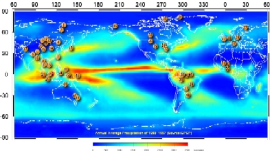
Global Runoff Data Center (GRDC)
http://grdc.bafg.de/
Chair: Ulrich Looser (looser@bafg.de)
The Global Runoff Data Centre (GRDC) was established in 1988 at the Federal Institute of
Hydrology (BfG) under the auspices of the WMO. It is a contribution of the Federal Republic of
Germany to the World Climate Programme Water (WCP-Water) of WMO. WMO mandates and
directly supports GRDC by its Resolutions 21 (Cg XII, 1995: Request to the member states to
provide GRDC with river discharge data) and 25 (Cg XIII, 1999: Free and unrestricted exchange
of hydrological data). An international Steering Committee is guiding and overseeing the
activities of the GRDC. The steering committee consists of representatives from WMO,
UNESCO, UNEP, ICSU, IAHS and partner data centres GPCC and the International
Groundwater Resources Assessment Centre (IGRAC).
The main objective of the GRDC is the worldwide acquisition, storage and dissemination of
historical and near-real-time river-discharge data in support of the predominantly water and
climate related programmes and projects of the United Nations (UN), their specialized agencies
and the scientific research community. Also there are various GRDC activities in the framework of the GEWEX. GRDC is recognized as
one of the hydrometeorological projects in GEWEX. As such the GRDC seeks to provide inputs
to the GEWEX/CEOP RHP and modeling efforts by providing improved data sets.
As of end-2007 the GRDC database holds world-wide discharge data of 7,332 stations in 156
countries featuring around 276,000 station-years of monthly and daily values with an average
time-series length of 37.7 years. Additionally the GRDC maintains the following four specialized databases:
- Arctic Runoff Database (ARDB) containing data from over 2400 stations specifically for the
arctic research community associated with the WCRP ACSYS (Arctic Climate System
Study) and the CLiC Project
- Terrestrial Network for River Discharge (GTN-R) database for near-real time data, a
contribution towards the Implementation Plan for the Global Observing System for Climate and to GTN-H
- European Terrestrial Network for River Discharge (ETN-R) database for near-real time
data, a GRDC contribution towards the European Flood Alert System (EFAS) under
development by the European Union (EU) Joint Research Centre
- European Water Archive (EWA) in support of the Northern European Flow Regimes from
International Experimental and Network Data (NE-FRIEND) research community
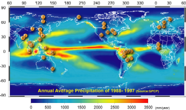
Global Precipitation Climatology Center (GPCC)
http://gpcc.dwd.de/
Chair: Tobias Fuchs (tobias.fuchs@dwd.de)
The Global Precipitation Climatology Centre (GPCC) was established in 1988 at the request of
the WMO. The Deutscher Wetterdienst (DWD, National Meteorological Service of Germany)
operates it as a German contribution to the WCRP. The mandate of GPCC is the global analysis
of monthly precipitation on earth’s land-surface based on in situ rain gauge data. Since its start,
the centre is the in situ component of the GPCP. In 1994, the long-term operation of the GPCC
has been requested by WMO in order to contribute to the climate monitoring activities of the
Global Climate Observing System (GCOS). Since 1999, GPCC has been a global GCOS Surface
Network Monitoring Center (GSNMC), which has a special emphasis on precipitation. Mid
December 2006, GPCC started its newest function as the WMO Commission for Basic Systems
(CBS) Lead Center for GCOS data for Europe. The German Meteorological Service (DWD)
continuously funds GPCC operation.
Main GPCC objective is the analysis of the spatial and temporal distribution of land-surface
precipitation on a monthly time-scale based on in situ rain gauge data compiled from stations
located worldwide. The aim of the GPCC is to serve user requirements esp. regarding accuracy
of the gridded precipitation analyses and timeliness of the product availability.
As of end-2007 the GPCC database holds world-wide precipitation data of more than 78,000
stations in more than 170 countries featuring more than 19,000,000 station-years of monthly
values. Over the past 12 months 40 countries have provided new or updated monthly
precipitation time series to GPCC. The GPCC products are adjusted to contribute to WCRP core projects:
- The GPCC Full data product is adjusted to support Global and regional
hydrometeorological research activities in the context of CEOP hydroclimate projects and studies.
- The GPCC VASClimO product is adjusted to support climate variability and change
studies in context of CLIVAR and contributes also to the IPCC Assessment Reports.
- The GPCC Monitoring product and the supplementary products related to solid/liquid
precipitation and systematic error correction are useful to support studies in context of
CLIC. In addition GPCC implemented the Arctic Precipitation Data Archive (APDA).
Top of this page
Home