
Objective 1: Produce consistent research quality data sets complete with error descriptions of the Earth's energy budget and water cycle and their variability and trends on interannual to decadal time scales, for use in climate system analysis and model development and evaluation.
Objective 2: Enhance the understanding of and quantify how energy and water cycle processes contribute to climate feedbacks.
Objective 3: Improve the predictive capability for key water and energy cycle variables and feedbacks through improved parameterizations to better represent hydrometeorological processes, and determine the geographical and seasonal characteristics of their predictability over land areas.
Objective 4: Undertake joint activities with operational hydrometeorological services, related Earth System Science Partnership Program (ESSP) projects like the Global Water System Project (GWSP), and hydrological research programs to demonstrate the value of GEWEX research, data sets and tools for assessing the consequences of climate predictions and global change for water resources.
Introduction
The Coordinated Energy and water cycle Observations Project (CEOP) is a merger of the previous World Climate Research Project (WCRP) Global Energy and Water-cycle Experiment (GEWEX) Hydrometeorology Panel (GHP) and the ‘Coordinated Enhanced Observing Period’ (‘CEOP’), which was an element of WCRP initiated by GEWEX. CEOP is now the international focal point for WCRP/GEWEX Global Hydrometeorological Research and we welcome all interested researchers to participate and contribute to the development of current and future hydrometeorological observations, simulations, and predictions.
Many of the former GEWEX Continental Experiments (CSEs) have evolved to more complete Regional Hydroclimate Projects (RHPs) and even beyond in that more than GEWEX efforts are now needed to solve regional problems involving a climate prediction focus (CLImate VARiations; CLIVAR) and a biological focus (International Geosphere Biosphere Program, IGBP).
In addition to the Regional Hydroclimate Projects, the new CEOP includes groups focused on regional studies in cold regions, high elevations, monsoon, and semi-arid regions. These groups are an outgrowth of the previous ‘CEOP’ Monsoon project, which attempted to bring together scientists within both the CSEs and CLIVAR. The new CEOP Monsoons Regional Study will also reach out to CLIVAR and the WCRP Monsoon crosscuts to make sure its activities are synergistically connected with these other groups. At the same time the new CEOP Regional Studies Cold Regions Study will begin to reach out to the RHP and WCRP scientists involved in similar activities in the WCRP CLImate and Cryosphere (CLiC) Project and will be a part of the International Polar Year (IPY).
The science of CEOP continues to provide a traditional focus on Water and Energy budgets, which will extend the efforts to understand average conditions to conditions during the ‘CEOP’ time period of 2003-2004 to present and a GHP effort to understand average conditions during an earlier period. This extension will have a special focus on extremes during the ‘CEOP’ period, which will be another connection to WCRP crosscut activities. New crosscutting CEOP science efforts include a study of the influence of aerosols and the studies of water isotopes, which is also connected to IGBP efforts.
CEOP now adds explicit global, regional, and land surface model studies, and Hydrologic Applications Project (HAP) as part of its group activities. All of these modeling groups are looking at an ensemble of international models in many different regions focused on the new CEOP reference sites described in the Data Management section. Some of these modeling projects expect to show not only their capability to simulate the present climate but also to predict at seasonal timescale (HAP) and also be useful for global change assessments in some of the RHPs.
CEOP Data Management has now successfully implemented a data policy allowing the sharing of in situ reference site data, model output data, and satellite data and set up archival centers of this data at the National Center for Atmospheric Research (NCAR) and the Max Planck Institute (MPI). During CEOP, satellite data will come on line at the University of Tokyo (UT) and then along with the other data be moved to a central data archive where it can be accessed and distributed to interested users. By the end of CEOP in 2012, we expect to have developed a functioning CEOP data center that will have been used by all five of the CEOP science groups. It should be noted that this CEOP data is already open to outside groups. CEOP data management is also in the process of developing links to a number of associated groups, such as the Global Runoff Data Centre (GRDC) and Global Precipitation Climatology Centre (GPCC).
General Background - GHP
When the GEWEX commenced in 1988 with a focus on global products, its lead scientists recognized that the global data sets needed to be evaluated at regional scales. At the same time significant improvements were being made to land surface models as a result of intensive regional experiments being carried out by the International Satellite Land Surface Climatology Project (ISLSCP) and the Biospheric Aspects of the Hydrologic Cycle (BAHC) initiative under the IGBP. In particular, the ISLSCP carried out intensive field campaigns focused on relatively homogeneous areas of 10,000 km2 (approximately the size of a climate model grid square) and involved intensive observational periods for (generally) two to four weeks several times a year. This concept continued to be developed by the US Dept. of Energy Atmospheric Radiation Measurement (ARM) program, who initially proposed world wide coverage with a number of sites, but ultimately, due to cost constraints, focused first on one site in Oklahoma, US and then later additional sites in Alaska and the western Pacific - sites which are still operating today.
As a result of the convergence of GEWEX interests for a regional test bed, the need to scale up the ISLSCP land surface studies to larger geographical areas, and the desire of the International Association of Hydrological Sciences (IAHS) to involve hydrology more actively in climate research, the concept of a continental scale hydrologic experiment was developed in 1990. The proposed regional experiment was based on the hypothesis that water and energy budgets over a large basin would not be as sensitive to random errors as they are at a point or for a small watershed, but they could still be examined in a meaningful way because there was an increasing likelihood of closing continental-scale water and energy budgets to acceptable limits using the newly available data sets and models.
In 1990, a group of international experts recommended the Mississippi River Basin as a focus area and then worked with others to draw up a science plan for the GEWEX Continental-scale International Project (GCIP). As planning progressed, however, a consensus emerged that areas with other important processes such as permafrost and tropical forests should also be studied. In addition, a number of countries could make stronger national contributions to GEWEX if they studied a basin that included their national territories. As a result several experiments were developed to cover large land areas. The GEWEX CSEs have included: MAGS (MAckenzie GEWEX Study), GCIP/GAPP/CPPA (GEWEX Continental-scale International Project/ GEWEX Americas Prediction Project / Climate Prediction Program for the Americas), LBA (Large-scale Biosphere Atmosphere Experiment in Amazonia), LPB (La Plata Basin), BALTEX (BALTic sea EXperiment), GAME/MAHASRI (GEWEX Asian Monsoon Experiment / Monsoon Asian Hydro-Atmosphere Scientific Research and prediction Initiative), MDB (Murray Darling Basin), AMMA (African Monsoon Multidiscplinary Analysis). These CSEs have had different start and end dates. For example, AMMA was approved as a CSE beginning in 2005 and MAGS, which began in 1994, ended in 2005. The Northern Eurasia Earth Science Partnership Initiative (NEESPI) will be proposed to the GEWEX Scientific Steering Group (SSG) in 2007.
GEWEX established the GHP beginning in 1994 to coordinate the wide range of regional interests and activities involved in these CSEs. GHP also took responsibility for coordinating relevant activities of the ISLSCP, the Global Runoff Data Center, and the Global Precipitation Climatology Center. The overall GHP mission was to “demonstrate the capability to predict changes in water resources and soil moisture at time scales up to seasonal and interannual as a component of the World Climate Research Program’s prediction goals for the climate system.” To this end GHP influenced the priorities of each CSE and global project. GHP further promoted and coordinated interactions with the GEWEX Radiation Panel (GRP) and the GEWEX Modeling and Prediction Panel (GMPP). GHP also initiated, synthesized, reviewed and recommended joint activities that promoted a common research agenda for each of the CSEs. CSE representatives agreed to a set of technical and scientific requirements, which have now been modified below.
GHP set up several international working groups composed of CSE representatives, which would attempt to globally coordinate diverse regional activities happening within each of the CSEs. These working groups included: WEBS (Water and Energy Budget Studies), WISE (Worldwide Integrated Study of Extremes), SWING (Stable Water Isotope Working Group), TWG (Transferability Working Group), WRAP (Water Resources Applications Project) / HAP, DM (Data Management), ‘CEOP' (Coordinated Enhanced Observing Period).
General Background - Coordinated Enhanced Observing Period ('CEOP')
‘CEOP’ was part of the initial GHP strategy to help coordinate the diverse GEWEX CSE activities to understand and model the influence of continental hydroclimate processes on the predictability of global atmospheric circulation and changes in water resources. As a contribution to ‘CEOP’, the CSEs identified high-quality in situ measurements at several global locations that would be able to provide coordinated global measurements during the period 2001-2004.
‘CEOP’, began as a discussion item at the 2nd GHP meeting in 1995 and subsequently, the ‘CEOP’ Working Group was formed, which was then moved from GHP in 2001 and the World Climate Research Programme Joint Steering Committee designated it as “an element of WCRP initiated by GEWEX”. ‘CEOP’ was strongly supported by GHP and many GHP science activities soon became actively entrained within ‘CEOP’, in part through the ‘CEOP’ data management and modeling activities, and in part through cross linkages of many of the CSEs and GHP science working groups within the ‘CEOP’ Intercomparison Monsoon Study (CIMS) and the Water and Energy Simulation and Prediction (WESP) project. ‘CEOP’ also took advantage of the coincident new generation of remote sensing satellites (including TERRA, AQUA, ENVISAT, ADEOS-II) in addition to TRMM, Landsat-7, NOAA-K series and the other operational satellites, which were providing enhancement of observing capabilities to quantify critical atmospheric, surface, hydrologic and oceanographic data during this time period. 200 km snapshots of the highest resolution raw radiances (with geographic location, i.e. level I) remote sensing data at the 35 in situ reference sites are archived. Geophysical products are being developed for these sites by international research teams as part of individual satellite science teams. In conjunction with the in situ and remote sensing observations, operational Numerical Weather Prediction (NWP) centers are also archiving both analysis/assimilation and short-term forecast/analysis model products from both global and regional modeling systems. Several model output variables (pertinent to atmospheric and surface water and energy processes) have been archived and the two types of requested model output, globally GRIdded Binary (GRIB) and site-specific Model Output Location Time Series (MOLTS) at each of the ‘CEOP’ International Reference Sites are being developed.
Rationale for the GHP/’CEOP’ merger
Now, initially ‘CEOP’ was a pilot experiment, designed to intensively study a limited time period, 7/1/2001-12/31/2004, a period when many CSEs would likely have corresponding intensive observation periods to complement ‘CEOP’ and a time when many of the new Earth Observing Satellites would be providing a wealth of new information about the earth. This pilot experiment was formulated and guided by formal Science and Implementation Plans and involved a number of technical and science driven working groups that were reviewed and received direction and oversight from a Science Steering Committee and an Advisory and Oversight Committee. With the demonstrated uniqueness of ‘CEOP’ and advent of CEOP, which will extend the time period of enhanced observations and enhance the science agenda, it is clear that ‘CEOP’ will contribute to the scientific objectives of GEWEX and integrated data management activities of WCRP on a much longer term.
As a result, GEWEX, in full agreement with the GHP, and with ‘CEOP’, decided at the GEWEX SSG meeting in January 2007, to merge GHP and ‘CEOP’ to form a new entity, now designated the Coordinated Energy and water cycle Observations Project (CEOP). This formal merger into the new CEOP is meant to enhance the efforts of both GHP and ‘CEOP’ and will not lose sight of any of the GHP and ‘CEOP’ strategic goals or any of the ongoing GHP and ‘CEOP’ science work since the same scientists and more are already working on closely related projects and goals. It does mean, however, a refocusing of the former GHP and ‘CEOP’ activities toward the new CEOP goal and objectives.
Organization
As summarized below, two Co-Chairs: Toshio Koike (University of Tokyo, Japan) and Ronald Stewart (University of Manitoba, Manitoba, Canada), now lead CEOP. A Chair or Co-Chairs also lead each of the individual CEOP elements. They are supported in this role by the International Coordinator, Sam Benedict, as well as the International GEWEX Project Office (IGPO).
| FUNCTION | REPRESENTATIVE | E-MAIL ADDRESS |
|---|---|---|
| CEOP Co-Chair | Toshio Koike | tkoike@hydra.t.u-tokyo.ac.jp |
| CEOP Co-Chair | Dennis Lettenmaier | dennisl@u.washington.edu |
| International Coordinator | Sam Benedict | sam.benedict@gewex.org |
| RHPs | ||
| AMMA | Amadou Gaye | atgaye@ucad.sn |
| BALTEX | Hans-Joerg Isemer | hans-joerg.isemer@gkss.de |
| CPPA | Jin Huang | jin.huang@noaa.gov |
| LBA | Jair Maia | jairmaia@inpa.gov.br |
| LPB | Hugo Berbery | berbery@atmos.umd.edu |
| MAHASRI | Jun Matsumoto | jun@eps.s.u-tokyo.ac.jp |
| MDB | Jason Evans | jason.evans@unsw.edu.au |
| NEESPI | Pasha Groisman | pasha.groisman@noaa.gov |
| Regional Studies | ||
| Cold Region Study Chair | Tetsuo Ohata | ohatat@jamstec.go.jp |
| High Elevations Chair | Gianni Tartari | tartari@irsa.cnr.it |
| Monsoon Co-Chair | Hugo Berbery | berbery@atmos.umd.edu |
| Monsoon Co-Chair | Jun Matsumoto | jun@eps.s.u-tokyo.ac.jp |
| Semi-Arid Study Chair | Congbin Fu | fcb@cb@tea.ac.cn |
| Cross Cutting Studies | ||
| WEBS Chair | Kun Yang | yangk@itpcas.ac.cn |
| Extremes Chair | Ronald Stewart | ronald.e.stewart@gmail.com |
| Aerosols Chair | William Lau | william.k.lau@nasa.gov |
| Isotope Co-Chair | David Noone | dcn@colorado.edu |
| Isotope Co-Chair | Kei Yoshimura | k1yoshimura@ucsd.edu |
| Model Studies | ||
| Global Models Chair | Mike Bosilovich | michael.bosilovich@nasa.gov |
| Regional Models: ICTS Chair | Burkhardt Rockel | burkhardt.rockel@gkss.de |
| Regional Models: SIEVE Chair | Ray Arritt | rwarritt@bruce.agron.iastate.edu |
| Land Surface Models Chair | Matt Rodell | matthew.rodell@nasa.gov |
| Hydrological Applications Chair | Eric Wood | efwood@princeton.edu |
| Data Management | ||
| Reference Sites/Basins Chair | Steve Williams | sfw@ucar.edu |
| Model Output Chair | Michael Lautenschlager | michael.lautenschlager@zmaw.de |
| Satellite Data Chair | Toshio Koike | tkoike@hydra.t.u-tokyo.ac.jp |
| Data Integration & Dissemination Chair | TBD | |
| Central Data Integration Chair | Kenji Taniguchi | taniguti@hydra.t.u-tokyo.ac.jp |
| Associated Global Data Centres | ||
| GRDC | Ulrich Looser | looser@bafg.de |
| GPCC | Tobias Fuchs | tobias.fuchs@dwd.de |
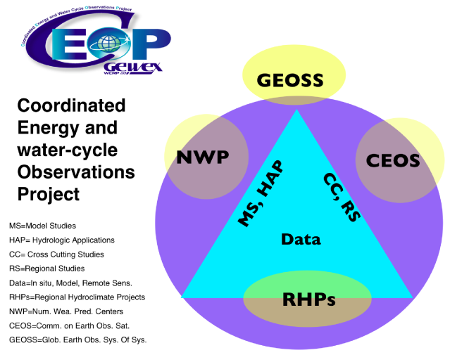
Figure 1: Overall Structure of the new CEOP project of GEWEX, showing the contributions by the RHPs, RS, MS and HAP, anchored by the Data Management. CEOP depends on community participation from the international NWP centers, Committee on Earth Observations (remote sensing) and intends to make a significant contribution to the evolving implementation of GEOSS. (Click on the image for a higher resolution figure).
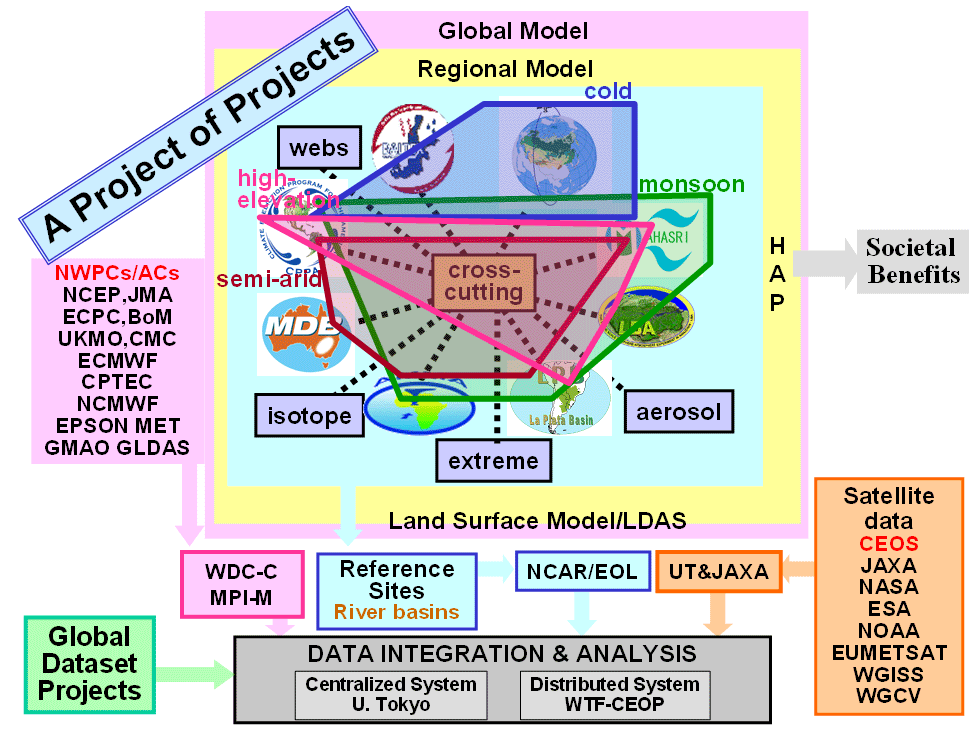
Figure 2: CEOP Framework Diagram. (Click on the image for a higher resolution figure).
|
|
|
Last Updated: 2010/07/16 12:13 (JST)
This web site is published by support of DIAS
© 2008-2010 CEOP: All Rights Reserved.