Implementation Plan
GEOSS/AWCI Implementation Plan, version November 2008:
 (MS Word: 12.1MB)
 (PDF: 4.6 MB)
Participants and Collaborators
--> Participating Countries
Currently, 20 countries from the Asia and Pacific region participate in the GEOSS/AWCI activities. These include:
Australia, Bangladesh, Bhutan, Cambodia, China, India, Indonesia, Japan, Korea, Lao PDR, Malaysia, Mongolia, Myanmar, Nepal, Pakistan, Philippines, Sri Lanka,
Thailand, Uzbekistan, and Vietnam.
--> Collaborating Projects, Institutes, and Organizations
The GEOSS/AWCI is a collaborative effort that involves number of national and international institutes and organizations contributing their expertise, data products
and data archiving, integration, and disseminating tools, modeling and analyzing systems, and other in-kind support. The main collaborators include:
- Japan Aerospace Exploration Agency (JAXA)
- International Centre for Water Hazard and Risk Management (ICHARM)
- United Nations University (UNU)
- Data Integration and Analysis System (DIAS)
- University of Tokyo (UT), River and Environmental Engineering Laboratory
- University of Tokyo: The Earth Observation Data Integration & Fusion Initiative (EDITORIA)
- Japan Agency for Marine-Earth Science and Technology (JAMSTEC)
- Global Earth Observation System of Systems (GEOSS)
- Asia-Pacific Network for Global Change Research (APN)
- Coordinated Energy and Water Cycle Observations Project (CEOP)
- Monsoon Asia Integrated Regional Study (MAIRS)
- Mekong River Commission (MRC)
- ...and others
Introduction
--> Establishing GEOSS/AWCI
Under the framework of GEOSS, representatives of hydrological and meteorological organizations and science communities in Asia gathered together, and began to
discuss about how to address the water-related issues in Asia in cooperative ways by making maximum use of GEOSS.
At the 1st Asian Water Cycle Symposium (AWCS) in Tokyo,
November, 2005, the participants recognized the common water-related issues and socio-economic needs. They shared ideas on the large natural variation of the Asian
monsoon and the big impacts of the human activities in Asia as their backgrounds.
To address these issues, they considered that well coordinated scientific and operational challenges and efforts should be launched by making maximum use of the GEOSS,
which is leading convergence and harmonization of observation activities, interoperability arrangements, and effective and comprehensive data management.
Then, they agreed to establish a basic plan for "Asian Water Cycle Initiative (AWCI) contributing to GEOSS" and to organize an International Task Team (ITT) for
drafting an implementation plan for demonstration projects.
Based on the discussions at the first ITT meeting and the International Workshop on Capacity Building "Earth Observations in the service of Water Management",
both held in Bangkok in September 2006, a baseline implementation plan for the GEOSS/AWCI demonstration projects was proposed at the
2nd AWCS in Tokyo, in January 2007.
The symposium fully approved the baseline idea and established the International Coordination Group (ICG) consisting of the national representatives and the working
group co-chairs for promoting the cooperative activities.
The 1st GEOSS/AWCI ICG meeting was held in Bali,
in September 2007. The update of each country activity was reported and the contents and procedure of the demonstration project implementation plan were discussed,
following the confirmation of the baseline implementation plan. The structure of the full AWCI Implementation Plan was presented, discussed, and agreed on at the
3rd Asian Water Cycle Symposium that was held in Beppu, Japan,
December 2007 as one of the open events of the 1st Asia-Pacific Water Summit.
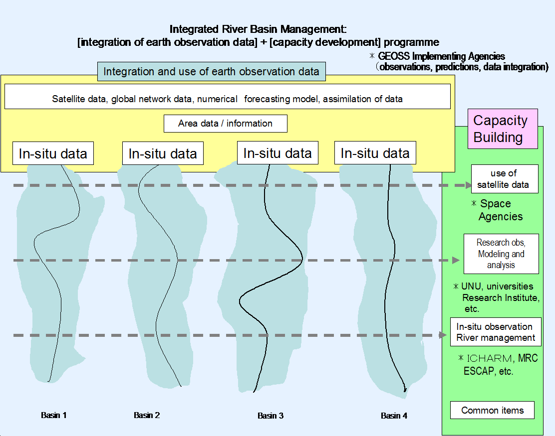
--> Observation Convergence, Data Integration, and Information Sharing
Observation convergence is essential for making possible advanced research into the water cycle phenomena and for transformation of the scientific findings into
the information usable for policy- and decision-makers to develop effective policies and make sound decisions in an Integrated Water Resources Management (IWRM) manner.
GEOSS/AWCI approach for converging earth observation satellites, in-situ reference site networks, and operational observation systems, for integration of the observed data,
numerical weather prediction model outputs, geographical information, and socio-economic data, and for dissemination of usable information is adopted from and designed
in cooperation with the Coordinated Energy and Water Cycle Observations Project (CEOP)
of the Global Energy and Water Cycle Experiment (GEWEX), World Climate Research Programme (WCRP). In addition to the data provided by CEOP, meteorological and
run-off data, dam operation data, geographical information including topography, land cover, and land use, population and socio-economic data are collected in the
GEOSS/AWCI Demonstration Project river basins.
As originally produced by the various sources, the data is in a wide variety of formats and structures. CEOP had developed a prototype data integration, analysis,
and dissemination system that has been further elaborated and expanded into the
Data Integration & Analysis System (DIAS), which was launched in 2006 as part of the Earth Observation and ocean Exploration System, which is one of five
National Key Technologies defined by the 3rd Basic Program for Science and Technology of Japan. DIAS provides cooperative opportunities for constructing GEOSS/AWCI
data archives, and developing data integration and analysis functions. A Standardized Metadata Model has been developed in cooperation with the international
standardization communities in order to assure full interoperability of the DIAS system.
In order to make maximum use of the global earth observation and prediction, GEOSS/AWCI employs downscaling techniques through which
local-to-regional scale information is produced from larger-scale GCM data. In cooperation with international science communities and research institutions, GEOSS/AWCI
(a) adopts and adapts existing downscaling techniques and (b) develops a new dynamical downscaling system coupled with satellite-based data assimilations and distributed
hydrological models. Through the use of the downscaling procedures, GEOSS/AWCI can disseminate usable information in a river basin scale or less for decision making on disaster
mitigation and water resources planning.
The basis for the GEOSS/AWCI collaborative framework is the mutual consensus among participating countries and international organizations that defines
data sharing and exchanging policy and responsibilities for data processing, management and archiving. Since the large part of the GEOSS/AWCI data, including the
reference site and satellite data and the NWP model outputs, are provided by WCRP/GEWEX/CEOP, it was appropriate to adopt and adapt the
CEOP Data Release and Dissemination Guidelines.
The GEOSS/AWCI Data Release and Dissemination Guidelines are available at the
Data page of this website.
--> Capacity Building
At the early stage of the deliberations on the GEOSS/AWCI establishment, a need for a well-defined capacity building program was recognized and
a basic framework of such program proposed. The goal of the GEOSS/AWCI Capacity Building program of is to facilitate and develop
sustainable mechanisms for the countries in Asia Pacific region to use advanced earth observations systems, associated data and tools for water cycle research
and water resources management under the GEOSS framework. The specific objectives of the program are to develop capacities of the Asian countries including:
- Techniques for downscaling regional and global information to basin scale and to improve accuracy required by operational water management applications
through a combination of numerical forecasting and fusion of local observations;
- Reliable and efficient tools for conversion of the available observations and data to useful information for flood management employing data transformations,
interpolation, classification, and estimation algorithms.
- Methodologies for conversion of information to water resources management applications, both for operational use and scenario based assessments for planning purposes.
The GEOSS/AWCI CB program recognizes three main target groups:
- Researchers & Scientists, where the emphasize is customizing existing knowledge to suit local conditions supported by global experiences;
- Professionals & Practitioners, which focuses on introducing new methodologies, tools and standards;
- Administrative & Local government officials, who are to be provided an overview of existing technology and science.
Different capacity development tools and programs will be combined to reflect the relevant emphasize and coverage for each target group.
--> Demonstration Basins
GEOSS/AWCI is a new challenge to lead in the solution of the water-related problems. It is effective to start with small-scale projects and to show early success
stories to stakeholders after intensive implementation. As the first step, one river basin was selected from each participating country as a target of a
demonstration project (DP), according to the following criteria:
- Importance of the basin from the viewpoint of the socio-economic benefit area and hydrological sciences
- Minimum requirement of data availability:
- a. Data type: rainfall, streamflow, weather station data (air temperature, wind speed, pressure, humidity);
- b. Spatial density of observation stations: according to the WMO standards but local specifics are to be considered;
- c. Watershed characteristics information.
- Highly expected data:
- d. Upper air observation is highly recommended
- e. Near-real time data availability is highly recommended;
- f. Ground water and water quality data availability are essential for the river basins where those problems should be addressed.
- Size of the watershed: 100 km2 - 1,000,000 km2
So far, 18 river basins were selected as DP targets. The location of the DP river basins and further information is available
HERE.
--> Working Groups
GEOSS/AWCI organizes four working groups:
- Flood WG
- Drought WG
- Water quality WG
- Climate change WG
Each WG covers both of the AWCI foci: "observation convergence, data integration, information sharing" and "capacity building"
and is strategically involved indemonstration projects.
Flood Working Group
The goal of this WG is to build up a scientific basis for sound decision-making and developing policy options for most suitable flood risk
management for each country and region in Asia, through the full utilization of new opportunities on global, regional and in-situ dataset under
the scheme of GEOSS AWCI.
To attain the goal, it is necessary to provide methodologies, tools and basic datasets to derive such required information to improve real-time
flood forecasting system for short-term crisis management (objective #1) and to assess flood risk and vulnerability and then to make flood scenarios
for long-term integrated flood risk management (objective #2).
Drought Working Group
The drought and water scarcity study is mainly based on the observation of precipitation, temperature and soil moisture by now, such as various
drought indices and moisture indices. The satellite products have not been widely used since lack of capacity building in many Asian countries.
Under the support of JAXA and Tokyo University, the retrieved soil moisture dataset from satellite remote sensing products are being used in the
Drought WG activities, and the related countries collaborators validate this data set by using the in-situ observation of soil moisture,
precipitation and temperature. The main objectives of the Drought WG are:
- To share and improve the drought monitoring capability in various Asian countries such as China, Pakistan, Thailand, Nepal and Philippines.
- To set up a drought monitoring and research network in related Asian countries.
- To help developing the early warning system of drought hazard in related countries.
Water quality Working Group
The overall goal of the Water Quality WG is to contribute towards sustainable management and development of water and health. The main objective
is to conduct a phased research on the scopes of institutions to develop appropriate water quality monitoring program for domestic water in
developing countries in Asia and disseminate the results. The specific objectives during the first phase include:
- Analysis of the roles, capacities, practices, policies, methods (and indicators), synergies, and needs in monitoring WQ by main water
concerned institutions in participating countries.
- Identification and comparison of the common and specific problems as well as the related best approaches in water quality monitoring and
conducting of a formative/indicative research to investigate preliminary appropriate water quality monitoring options for domestic water
by in-situ and satellite measurements based on selected specified indicators.
- Develop policy recommendations on how the institutions and countries can make attempts for appropriate water quality monitoring.
- Identification of proper hydrological models for coupling with water quality models and application of such coupled system for addressing
water quality issues during various flow regimes.
- Exploring possibilities to use remote sensing data for water quality issues and an access to such data for watershed management monitoring.
Climate change Working Group
Climate Change WG was formed at the Beijing meeting in November 2008 in a response to a growing concern of the GEOSS/AWCI participating countries
about possible impacts of projected climate changes on water resources and water-related hazards. The group's agenda include two main focuses:
- Historical observation data analysis for finding the evidence of climate change.
- Future projections by GCM outputs from specific greenhouse gas emission scenarios, downscaling and hydrological model applications.
Although several countries have developed their own methods for climate change impact assessment and provided local hydrologic impacts, their
results include high uncertainties due to the inconsistent methodologies used and lack of model calibration/verification. From these reasons,
sharing the common method and observation/simulation data for both climatology and hydrology is very important for climate change impact
assessment on water resources including flood/drought over the Asia-Pacific regions. One of the best ways to minimize model uncertainties is
the use of Multi Model Ensemble (MME) approachs. The obtained results of such analyses can then be provided to decision-makers for their
future water resources planning and management.
Organization
To promote international cooperation and project management, GEOSS/AWCI established the International Coordination Group consisting of a national
representative of each member country, working group co-chair, invited experts and secretariat.
--> Country Representatives
| Country | Name | Affiliation |
|---|
| Australia | Stuart Minchin | Commonwealth Scientific and Industrial Research Organisation (CSIRO) |
| Bangladesh | Ashfakul Islam | Bangladesh Ministry of Defense |
| Bhutan | Karma Chhophel | Hydro-met Services |
| Cambodia | So Im Monichoth | Department Hydrology and River Works |
| China | Qian Mingkai | Huaihe River Commission, Ministry of Water Resources |
| India | Surinder Kaur
Rakesh Kumar | India Meteorological Department
National Institute of Hydrology |
| Indonesia | Joesron Loebis | Research Institute for Water Resources |
| Japan | Toshio Koike | The University of Tokyo |
| Korea | Deg-Hyo Bae | Sejong University |
| Lao PDR | Chanthachith Amphaychith | Lao National Mekong Committee |
| Malaysia | Ahmad Jamalluddin Shaaban | National Hydraulic Research Institute of Malaysia |
| Mongolia | Gombo Davaa | Institute of Meteorology and Hydrology |
| Myanmar | Tin Yi/Htay Htay Than | Dept. of Meteorology and Hydrology |
| Nepal | Shiv Kumar Sharma | Department of Water Induced Disaster Prevention |
| Pakistan | Bashir Ahmad | Water Resources Research Institute/ National Agriculture Research Center |
| Philippines | Flaviana Hilario | PAGASA/DOST |
| Sri Lanka | S. B. Weerakoon | University of Peradeniya |
| Thailand | Thada Sukhapunaphan | Ministry of Agriculture and Cooperatives |
| Uzbekistan | Sergey Myagkov | Hydrometeorological Research Institute |
| Vietnam | Dang Ngoc Tinh | National Hydro-meteorological Forecasting Center |
--> Working Group Co-Chairs
| Working Group | Name | Affiliation |
|---|
| Flood | Kazuhiko Fukami
Srikantha Herath | ICHARM, Japan
UNU, Japan |
| Drought | Ghulam Rasul
Ichirow Kaihotsu | Pakistan Meteorological Department
Hiroshima University, Japan |
| Water Quality | Bilqis Amin Hoque
Hiroaki Furumai | Environment and Population Research Center, Bangladesh
University of Tokyo, Japan |
| Climate Change | Deg-Hyo Bae
Mafizur Rahman | Sejong University, Korea
BUET, Bangladesh |
--> Invited Experts
| Expertise | Name | Affiliation |
|---|
| Satellite | Chu Ishida | JAXA, Japan |
| Hydrological Modeling | Dawen Yang | Tsinghua University, China |
| Integration | Hansa Vathananukij | Kasetsart University, Thailand |
--> AWCI Secretariat at the University of Tokyo, EDITORIA
Akiko Goda, Petra Koudelova, Katsunori Tamagawa, Tetsu Ohta